In Part 1 of this 4-part series, Jami Fitch, the Town of Scarborough’s Sustainability Manager, explains some of the risks and tradeoffs our community will face in the coming decades. Future articles will focus on impacts to public infrastructure and homeowners, and the town’s emissions reduction efforts. Thanks, Jami.
By Jami Fitch
Scientists have been saying it for decades: over a century of burning fossil fuels has put more carbon dioxide into the atmosphere, resulting in shifting patterns in nature. Around the world, people are facing the impacts of more frequent and stronger natural disasters like prolonged droughts, severe storms, and wildfires. The effects of climate change in Maine have been more subtle. High tides are getting a little higher—measurable, but not so noticeable. Winter storms are often more rain and ice than feet of snow. Summers are longer and “gully washers” happen more often. Ticks and rates of tickborne illnesses are on the rise.
Climate Change Hits Scarborough
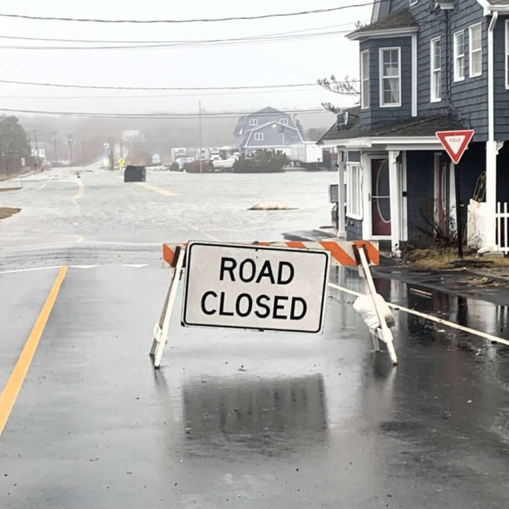
These effects became much more obvious on a local level in early 2024, when Scarborough experienced back-to-back coastal storms that coincided with astronomical high tides.* The gale-force winds that accompanied the storms blew out of the southeast, pushing water into our marshes. These “perfect storm” conditions caused many areas of town to flood, cutting off roads all over Scarborough. Private property and public infrastructure sustained significant damage, especially in our beach neighborhoods that faced the full brunt of the storms. The effects of climate change were on our doorstep.

Assessing the Risks
As the storms raged, the Town of Scarborough was already preparing for the future. Work was underway on a vulnerability assessment to make our community resilient to climate hazards like coastal flooding and storm surge. The detailed analysis identified current and anticipated risks and outlined adaptation strategies to help prioritize projects that improve our ability to recover from storms, floods, and other disruptions.
The assessment evaluated the coastal flood risk of public roads, infrastructure, and neighborhoods in Scarborough. Thirty public roads are currently vulnerable to coastal flooding—a number expected to double by 2050. Not surprising, the areas of Scarborough most vulnerable to climate change are those that face the ocean or touch the marsh. These low-lying areas are already prone to flooding during highest astronomical tides, or “king tides,” which typically happen at least once per year and affect many roads and properties in Scarborough. Experts predict these periodic highest-tide levels will become our daily high tides within the next 15 years.
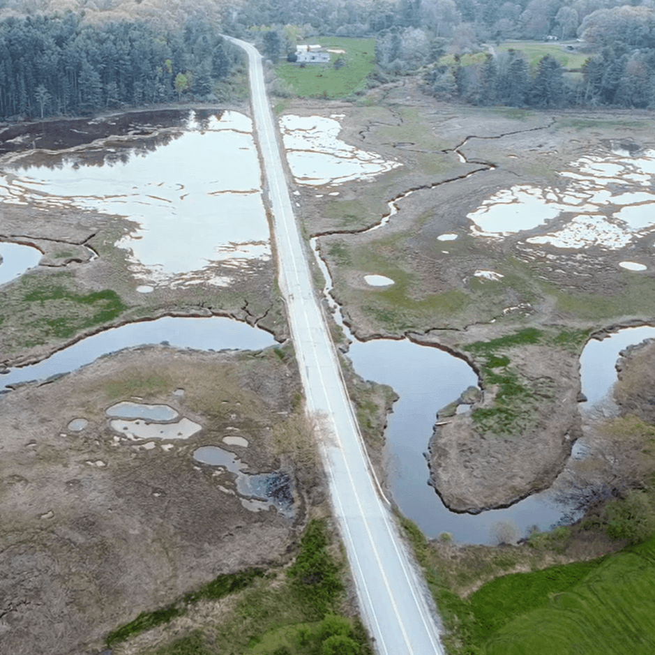
Tale of Two Roads
Bayview Avenue at Higgins Beach (left) sustained significant damage in the January 2024 storms because it is exposed to the full force of the ocean. Payne Road (right) was closed due to flooding but experienced minimal damage during the storms because it is protected by Scarborough Marsh. This illustrates how coastal marshes protect property and infrastructure by absorbing energy from waves and storms. Photos courtesy of Town of Scarborough.


Hard Choices
With so much at risk, Scarborough has hard decisions to make to prepare for the conditions we will face in the not-too-distant future. Do we shore up our infrastructure, like raising the roads and enlarging the culverts, likely costing millions of dollars? Do we remove infrastructure from sensitive areas? These types of questions will be asked more often as the Town faces the reality of our changing climate.
Building a More Resilient Scarborough
In addition to bolstering resiliency in the face of stronger storms and sea-level rise, the Town of Scarborough is working to protect its natural areas. Forests and wetlands collect and store carbon from the atmosphere, making them important tools to combat climate change. In 2023, the Town Council passed a 30×30 resolution, which aims to conserve 30% of land in Scarborough by 2030. Scarborough voters approved a $6 million bond to help reach the 30×30 goal. The Town also developed an Open Space Plan, pinpointing more areas to conserve for wildlife habitat, recreation opportunities, clean water, agriculture, etc. Since the Plan was adopted in April 2025, an additional 328 acres have been protected, making Scarborough nearly 24% conserved.
Community Action
Community support is essential as the Town of Scarborough grapples with major decisions and worsening climate risks. The Town is currently working with experts on Sustaining Scarborough, a community-supported Climate Action Plan that will be a practical, responsible, and crucial roadmap to reduce greenhouse gas pollution. The process will help us understand where emissions are coming from throughout the entire community and develop strategies to reduce climate pollution. Based on a pollution analysis, the two biggest sources of emissions in Scarborough are from vehicles (44%) and building energy use (40%).

In the coming months, there will be opportunities for all ages to get involved in developing the action plan. Check out the quick polls on the Town’s social media pages and in the Town email newsletter to give feedback, and look for the Sustaining Scarborough team at events throughout the spring and summer. Visit SustainingScarborough.org to learn more about the plan and opportunities to participate.
Preparing for the impacts of climate change and reducing greenhouse gas pollution require collective action from all corners of the community and beyond. Throughout 2026, we’ll take a deeper dive into what Scarborough is doing to be ready and resilient, and highlight steps you can take to be part of this effort. Now is the time for us to work together to keep our neighborhoods safe, our air and water clean, and make sure future generations can enjoy the quality of life for which Scarborough is known.
LEARN MORE
Scarborough’s Vulnerability Assessment: ScarboroughMaine.org/VA
Progress toward the 30×30 goal: ScarboroughMaine.org/OpenSpace
NOAA Sea Level Rise Map: Coast.NOAA.gov/slr
State of Maine’s Climate Action Plan: Maine.gov/climateplan/
Maine Infrastructure Commission (Formed after the 2024 storms): Maine.gov/future/infrastructure-commission
*An astronomical high tide is the highest possible tide. It occurs when the moon and sun are positioned so their gravitational pulls on the ocean align.
Jami Fitch is Sustainability Manager for the Town of Scarborough.
Top photo: Pine Point Road closed due to flooding during the January 13, 2024 storm. Photo courtesy of Town of Scarborough.