In Part 2 of a 4-part series on climate change, Jami Fitch, the Town of Scarborough’s Sustainability Manager, explains how rising sea levels and extreme weather events will impact Scarborough’s public infrastructure. Thanks, Jami.
By Jami Fitch

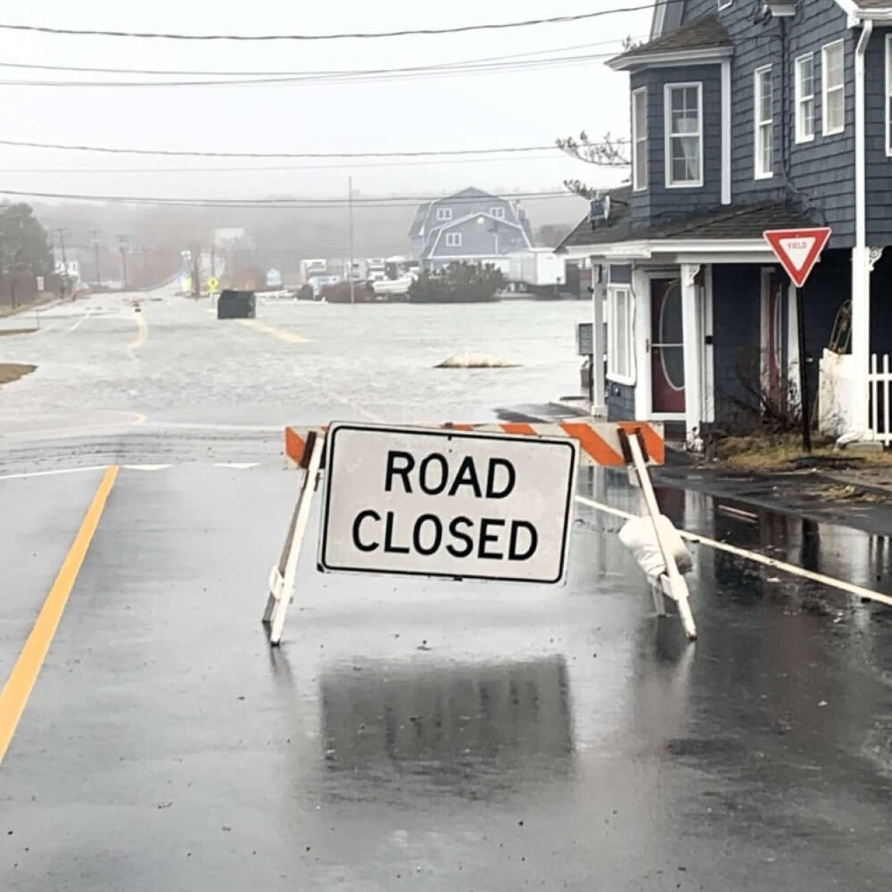
The Maine saying, “you can’t get there from here” doesn’t typically apply in Scarborough. We’re well positioned at the interchange of I-95 and 295, and U.S. Route 1 bisects the town from South Portland to Saco. It’s usually pretty easy to get around town, but we are starting to see how weather events can affect our mobility. Two extreme storms in January 2024 revealed Scarborough’s most vulnerable infrastructure. Major roads like Route 1, Route 9/Pine Point Road, Payne Road, and Black Point Road were all closed due to flooding, and many smaller roads were also impassable. The Higgins Beach and Pine Point neighborhoods were largely cut off. “You can’t get there from here” was a reality faced by many.
Road closures due to high tide flooding or coastal storms are becoming more common and bring a host of other challenges for the Town to consider. Scarborough’s 2025 Vulnerability Assessment identified more than 30 public roads that are at risk of flooding today. That number jumps to 62 by 2050 and over 100 by 2100. At-risk roads were determined by both the likelihood of flooding and its potential impact. For example, evacuation routes or roads that serve several homes or businesses were weighted higher than roads that lead to few homes. The Vulnerability Assessment also considered the likelihood of damage to the road and potential environmental and economic impacts.

With this information, Scarborough is developing plans to address some of our most vulnerable roads. For most, the solution will include raising the road and installing larger culverts to allow tides to pass under, rather than flow over. In some cases, roads may be closed or rerouted away from sensitive areas.
Supporting a Healthy, Protective Marsh
Salt marshes provide many benefits to coastal communities. Most notably, a recent study by the Massachusetts Institute of Technology found they provide more protection from storm surge than engineered solutions alone, an asset that will become even more important to Scarborough as extreme weather events become more common. Salt marshes reduce storm damage by absorbing energy from waves and storm surge. They also filter pollution from runoff, collect and store carbon from the atmosphere, provide countless recreational opportunities, are nurseries for fish, and provide important habitat for birds and other wildlife.
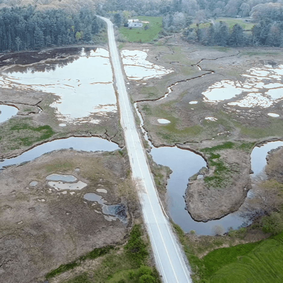
Many roads in Scarborough cut through salt marshes and have culverts that are far too small and restrict the flow of water, impacting the marshes’ health and function.
Sea level rise puts salt marshes at risk because marsh grasses need periods without standing water to survive. Rising sea levels mean parts of our marshes will remain submerged, drowning the plants and turning the marsh into a mudflat or shallow inlet. Under the right conditions, marshes can move or “migrate” inland. In Scarborough, marsh plants are already spreading to low-lying areas next to the marsh. Tidewaters also carry sediment inland. When the sediment settles out, it builds up sections of the marsh and creates higher areas for plants to grow. This process is called “marsh accretion.” For marsh migration and accretion to happen, marshes can’t be blocked by roads, seawalls, or other barriers.
Studies have shown that most marshes should be able to increase their elevation to keep pace with sea level rise if tidewaters are able to move freely upstream. Most of Scarborough’s tidal culverts will need to be replaced with much larger structures to achieve “tidal transparency,” or unrestricted flow through the culvert. Installing larger culverts may result in a greater volume of tidal water flowing upstream, resulting in more flooding, so tidal culvert projects need to be carefully planned, modeled, and designed. The extensive design process and larger structures mean these projects will cost several million dollars.
Investing in Resilience
Making roads and other infrastructure resilient to flooding will require Scarborough to make significant investments, but the cost of inaction is projected to be even higher. A study by the U.S. Chamber of Commerce, Allstate Insurance, and the U.S. Chamber of Commerce Foundation found that underinvestment in resilience today can cost communities even more when disaster strikes – up to $33 in lost economic activity for every $1 not spent.
Since 2022, the State of Maine has provided grants to help municipalities improve their infrastructure in the face of climate change. The modest grants are often used for engineering because they don’t typically provide enough funding to complete a full project. Scarborough has applied for and received funding for multiple projects through these grant opportunities.
Federal legislation, like the 2021 Bipartisan Infrastructure Law (BIL), provided significant federal funding for resilience projects. Unfortunately, most of the BIL programs have been discontinued, which shifts the burden of paying for these projects to state and local governments.
Between the number and scale of the projects, limited outside funding, and competing priorities, the Town of Scarborough will be forced to make hard choices when it comes to our road infrastructure. How we “get there from here” will depend on many factors: the cost of improvements, opportunities for grants or other funding, road usage, and availability of alternate routes. In vulnerable areas, road work will look different than it has in the past. Residents can expect to hear about resilience projects more often during budget discussions and as grants become available.
SPOTLIGHT ON SCOTTOW HILL ROAD


The culverts under Scottow Hill Road partially collapsed in May 2025 due to their age and poor condition. The culvert failure has resulted in an ongoing road closure. Photos courtesy of Town of Scar-borough.
The tidal culvert crossing on Scottow Hill Road partially collapsed in May 2025, resulting in the ongoing closure of the road. The culverts are undersized and restrict both tidal flow upstream and Beaver Brook flowing downstream. The Town is considering two options for the road: remove the culvert and discontinue a portion of the road, or replace the culvert with a larger structure. Cul-vert removal would cost about $900,000 and replacement would cost about $4,000,000.
The Town applied for and received a $562,000 grant from the Maine Natural Resources Conservation Pro-gram to remove the culverts, discontinue a portion of Scottow Hill Road, and restore Beaver Brook and adjacent sections of Scarborough Marsh. The Town has not accepted the grant yet.
Scarborough has also applied for a $3 million grant from the Maine Infrastructure Adaptation Fund (MIAF) to replace the culverts with one large structure that will improve the flow of water both upstream and down-stream.
We will know if the MIAF grant ap-plication is successful later this sum-mer. A decision on the future of Scottow Hill Road will be made at that time.
LEARN MORE
Scarborough’s Vulnerability Assessment: ScarboroughMaine.org/VA
Progress toward the 30×30 goal: ScarboroughMaine.org/OpenSpace
NOAA Sea Level Rise Map: Coast.NOAA.gov/slr
State of Maine’s Climate Action Plan: Maine.gov/climateplan/
Maine Infrastructure Commission (Formed after the 2024 storms): Maine.gov/future/infrastructure-commission
Jami Fitch is Sustainability Manager for the Town of Scarborough.
Top photo: Sawyer Street cuts through Spurwink Marsh. Photo courtesy of Town of Scarborough.